


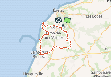
camping Antijune_retour par Cap d'Antifer

gdela
User

Length
23 km

Max alt
135 m

Uphill gradient
365 m
Km-Effort
28 km

Min alt
33 m

Downhill gradient
366 m
Boucle
Yes
Creation date :
2020-07-26 16:39:04.007
Updated on :
2020-07-26 16:40:54.447
--
Difficulty : Medium

FREE GPS app for hiking
 SityTrail
IGN / Geographical institutes
SityTrail Plus
The world is yours!
About
Trail On foot of 23 km to be discovered at Normandy, Seine-Maritime, Le Tilleul. This trail is proposed by gdela.
Positioning
Country:
France
Region :
Normandy
Department/Province :
Seine-Maritime
Municipality :
Le Tilleul
Location:
Unknown
Start:(Dec)
Start:(UTM)
298994 ; 5507113 (31U) N.
Comments